Travel infrastructure – or lack thereof – affects almost all of us. Dangerous junctions pose significant risks to motorists, cyclists, and pedestrians alike, often resulting in accidents and traffic congestion. Poorly maintained roads and inconsistent transportation policies further hinder economic growth and environmental sustainability. The lack of infrastructure supporting active travel, such as walking and cycling, limits healthier, more sustainable travel choices for many.
With a new Labour government ushered in, it has never been more important to stress the need for improvement across the sector. The loss of over £200m from the DfT’s active travel budget last year is a sign of the gap that needs to be filled.
Travel should be accessible to all, good infrastructure is the backbone of this accessibility, and effective infrastructure relies on quality data. The new government has a fresh opportunity to support local authorities by prioritising transportation reforms that not only enhance safety and efficiency but also drive economic prosperity and focus on sustainability.
Data-driven infrastructure
If local authorities don’t have access to accurate and timely data, they are taking a shot in the dark about where infrastructure changes are required and how they can support vulnerable road users (VRUs). But when they do have it, how can they use it to best improve the travel experience and enable safer active travel?
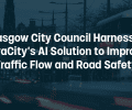
Watch the Transport for West Midlands and VivaCity webinar and learn more about how TfWM have used VivaCity’s Smart Road Safety dataset and tools to make roads safer in the region and protect vulnerable road users.
FIND OUT MORE
The optimum strategy uses a blend of data sources to understand travel trends and uptake on both a macro and micro scale. For example, seeing how an intervention has contributed to active travel in a certain area. Or seeing how one junction is more prone to accidents than others.
On a broader scale, reported DfT data is useful for evaluating trends and accidents over a longer period and making retrospective changes, while sources such as Google Maps and Strava can show popular travel routes for pedestrians and cyclists and where new/improved infrastructure could enhance the active travel experience and overall traffic flow.
On a granular scale, technology like AI-powered computer vision sensors offer a variety of traffic datasets all from a single device. This technology can capture the pathways, speed and counts of VRUs passing through a specific point and outline their interactions with other road users. Having the ability to cleverly combine paths and speed data, for example, allows for a deeper understanding of the real risk exposure to VRUs. This gives real-time insight into any high risk near misses with motorised vehicles and can indicate where wider lanes or extra pavement space can help improve safety.
This is particularly useful for monitoring newer travel modes like e-bikes and e-scooters, which have created more interactions in previously bicycle-only lanes. Currently, traditional forms of data collection and outdated legacy equipment don’t separate or cannot detect these different modes.
Tip: VivaCity’s can detect e-scooters and cyclists to reveals how new micromobility modes are using the network space
🔎 Case study: Exploring e-scooter trends in Bristol
Above all, data is key to building a strong evidence base that can provide answers and inform decisions. For example, this junction is overcrowded at these times so signal optimisation using real-time, multimodal data inputs can improve flow and user experience, or this intervention has successfully led to an increase in cyclists on this route. Conversely, gaps in data show where more technology is needed to assess where interventions are needed and whether they have been successful.
Data-driven resource allocation and investment
Data-driven insights are not only key to making direct improvements to infrastructure, but they also help local authorities and larger bodies allocate resources more efficiently, ensuring improved investments in infrastructure. They give authorities a chance to assess why trends are what they are. The more data that can be gathered and accessed across a town, city or region, the better authorities can see where resources and investments are required.
This also means that investments are much more likely to pay dividends. The reason departments like the DfT can lose funding is if there is a lack of evidence that their investments into active travel schemes have had their desired effect – to increase active travel levels. If authorities can demonstrate how schemes are working and their true impact on communities, they can form the case for future and larger funding.
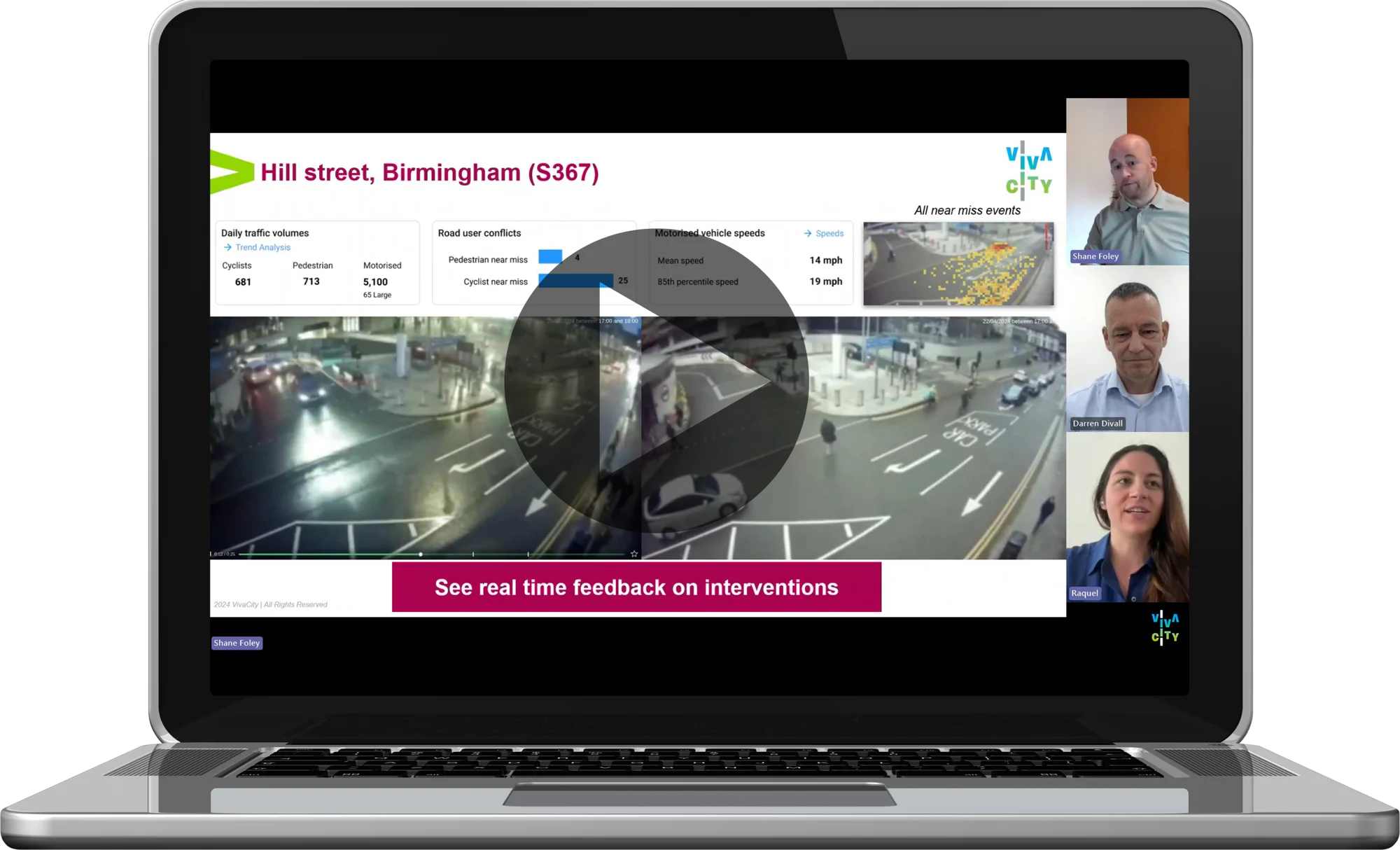
Watch the Liverpool City Region Region and VivaCity webinar to learn about how the combined authority has been building a strong evidence base using VivaCity’s Smart Traffic data to evaluate scheme success and secure further and bigger funding.
FIND OUT MORE
And in the case of active travel, which is not just a transport issue but a wider public health challenge, the right data can be used to open up avenues for partnerships with public health teams on prescriptive programmes, for instance, and alternative funding pots.
A data-driven transport system
There’s not much in business these days that doesn’t use data. If you can understand customer behaviour, you can offer better services. But while a Tesco Clubcard or cookies on a website can directly collect customer data, it’s not as straightforward to accurately understand travel patterns on our roads. And unlike other transport services like the tube, there are no entry and exit points to track data.
“Too little is known about the quality of the infrastructure that has been built,” said a report by the Public Accounts Committee on DfT active travel targets and its funding cuts. “DfT has an incomplete understanding of what has been built because the majority of schemes have cost less than the amount required to monitor or evaluate them.”
Many pockets of the country will still have neglected infrastructure as the data isn’t there to support funding to improve it – or to even know about it in the first place. If larger bodies like the DfT can see trends on a city, regional and national scale then they can most effectively divvy up funds to support sustainable travel nationwide. This comes from having up-to-date and accurate data.
By using multiple data points across a network, and combining data sources with other technology such as connected vehicles and pollution sensors, there are authorities cleverly building an interconnected data framework. This combination of data gives them an understanding of how people and objects travel across the wider transport network and how it impacts communities. The aim being that data can be collected across the country, shared between locations and neighbours, and available for authorities on a large scale.
Data accessible for all
With continuous, downloadable data collection available through VivaCity’s cloud-based dashboard, local authorities are able to log in from anywhere and view both live and historic data being generated by each sensor. This data can be accessed through VivaCity’s API providing 3rd party system integration, giving a holistic view of the network in an easily shareable format. For both early stage evidence building and longer-term monitoring schemes, these valuable insights can be the key to unlocking essential funding needed to make impactful network improvements.
A golden opportunity
The perception of road safety by VRUs combined with the lack of adequate infrastructure is often the biggest hurdle to overcome in encouraging sustainable travel. While marketing campaigns are a key component for shifting mindsets, improved infrastructure provides a tangible way of creating this shift; if something feels and is safer, it is more likely to encourage people to use said scheme.
There’s no hiding the fact that you can’t improve infrastructure – and, even more importantly, monitor it – without funding. But again, data can act as the incentive to provide money for schemes or show where resources are most needed at a given time.
With road infrastructure and safety a key priority over the next term, the new government has a golden opportunity to harness data to deliver a more sustainable, equitable and accessible transport system. Data is the key to this mission.
Get more from your technology with VivaCity’s 3-in-1 solution
With ongoing pressure on budgets it’s important to make the most of any technology you deploy. Versatility is key. VivaCity sensors can be used for three purposes: road safety, signal control and traffic monitoring. VivaCity sensors are always connected, so there’s no need to add all features at the point of installation – you can add them as and when they’re needed. When used in combination, the datasets unite to provide holistic and fully comprehensive insights and performance metrics, all from the same sensor.

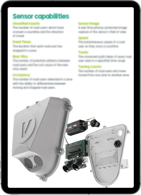
Explore VivaCity’s range of capabilities:
Discover What Makes VivaCity’s AI-Powered Computer Vision Sensor Technology Unique
Like our content? Sign up to our newsletter and receive the latest updates in your inbox.