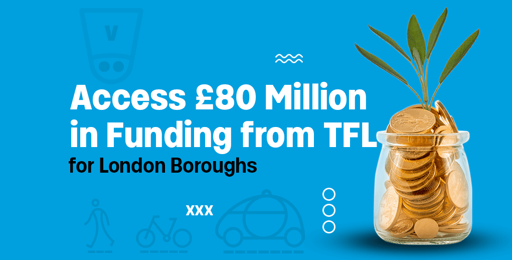
Transport for London is making up to £50M of funding available for London boroughs to improve road safety via the Borough Safer Streets funding, and £30M to improve bus journey times and increase ridership via the Better Bus Partnerships funding.
These are aimed at transforming the local areas and supporting London’s Vision Zero goals of eliminating death and serious injury from the transport network, and making bus service more comfortable and easy to use for all.
Borough Safer Streets funding
£50 million is available to boroughs over the next three years to deliver significant safety improvements in their local area by reducing speeds and tackling the city’s most dangerous roads and junctions. It’s open to projects between £0.5 million and £5 million, with schemes including:
- Projects that look to improve safety by reducing speeding and help to reduce the risk and severity of collisions
- Projects that develop improvements to protect vulnerable road users and improve safety for people walking and cycling
- Road safety improvements in high-risk locations
Better Bus Partnerships funding
£30 million in funding is available, and £10 million will be made available for three successful boroughs to deliver transformational bus infrastructure and operational improvements. The schemes can include:
- New bus priority measures to improve journey times
- Better management of road works to reduce delays to buses
- Improvements to stops and stations to make it easier to change between buses and other modes of transport
- Improvements to streets to make it easier to walk to bus stops and stations.
Boost your schemes with VivaCity data and secure funding
Schemes can be complex to deliver, and they often lack the high quality data needed to assess their performance. London Boroughs can benefit from VivaCity transport data in the development, implementation and evaluation of schemes, particularly supporting road safety and active travel.
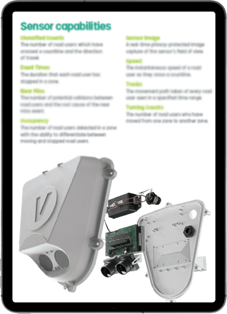
A single VivaCity AI-powered computer vision sensor offers real-time, multimodal traffic data on 13 classes of road users’ behaviour and trends. This includes road safety datasets such as speed, tracks (pathways), and our groundbreaking Near Miss detection; monitoring datasets such as classification, counts, journey times, zonal occupancy; and multimodal detection for smart signal control optimisation.
Independently verified by Transport for London, VivaCity sensors achieve a market-leading 97% accuracy rate. Currently, there are approximately 1,000 live VivaCity sensors across London supporting TfL and London boroughs with high quality transport data.
.
Build a strong Smart Road Safety strategy with VivaCity’s data
For too long road safety assessment, planning and decision-making has been based on analysing the causes of incidents after-the-fact. This cycle needs to be broken, if Vision Zero goals are to be achieved. Road safety decision making must shift from being a reactive process to a proactive one.
VivaCity’s Smart Road Safety tools have been designed to dig deeper, providing the most intricate datasets to get to the core of the most complex Road Safety issues. Here are a few examples of how to use our road safety datasets:
Identify and quantify the risk of collisions on a stretch of road and identify the prime root causes
⭐ Use tracks to understand how road users use the road space and speed to understand their risk exposure. Then use Near Miss data to zoom into specific conflicts to understand the severity of interactions before they become KSIs
🔎 Learn more about VivaCity’s Near Miss feature
E-scooter and cyclist detection reveals how new micromobility modes are using the network
⭐ Use classified counts and tracks to identify micromobility modes and their behaviour on a specific site
🔎 Case study: Exploring e-scooter trends in Bristol
Monitor 20mph zones to understand the impact on active travel uptake
⭐ Countline speed and classified counts can be used to measure the speed of specific road users; pre-scheme baseline data collection of active travel models using classified counts and post-scheme comparison can unveil the variations and if the scheme is delivering the desired goals
🔎 Case study: 20mph trial evaluation with Kent County Council
Identify dangerous movement patterns occurring at a junction intersection
⭐ Use Turning counts and classified counts to collect junctions behaviour insights and understand how certain sites can pose a risk to vulnerable road users
🔎 Discover the various transport datasets available from a VivaCity sensor
Plan and evaluate School Streets
⭐ Classified counts, tracks and speed data can be used to collect baseline data on a desired school street; post-implementation datasets such as classified counts, tracks and strategic countlines can be deployed to understand the increase of walking, cycling and wheeling on a school street, as well as if the designated crossings and pathways are being adhered to
🔎 Case study: Monitoring and Evaluating School Streets Trials in Westminster
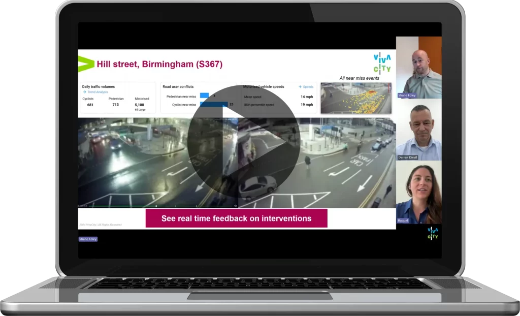
Watch the Transport for West Midlands and VivaCity webinar and learn more about how TfWM have used VivaCity’s Smart Road Safety dataset and tools to protect vulnerable road users and make roads safer in the region.
Enhancing Bus services and user experience with VivaCity
Key to decarbonising the road network and achieving Net Zero, increasing bus use is also fundamental to levelling up. Studies have shown that the major barrier to bus travel is service inconsistency, with passengers’ top priority for improvements being punctuality and reliability. Congestion is considered to be a key factor of bus use decline.
VivaCity’s above-ground computer vision traffic sensors offer a powerful tool for improving bus services. Here are a couple of examples on how to deploy VivaCity’s technology to enhance bus services:
Assess current performance to design improvement plans by collecting baseline data
⭐ Average bus journey time data that can be compared across the day, week and month; Dwell Time data to quantify congestion and identify trends across the day, week and month; use active travel path (using tracks) data to understand how connections are made between bus travel, walking and cycling hubs
🔎 Discover the transportation datasets available form VivaCity’s sensor technology
Make buses the priority: responsive bus prioritisation with VivaCity’s Smart Signal Control: Detect
⭐ Detect, integrates real-time multimodal data into existing traffic control systems, enabling responsive and accurate bus prioritisation through key junctions governed by real-time demand
🔎 Learn more about VivaCity Smart Signal Control: Detect solution

Let us help you plan your road safety and bus service improvement schemes with VivaCity’s smart traffic solutions
Get more from your technology with VivaCity’s 3-in-1 solution
With ongoing pressure on budgets it’s important to make the most of any technology you deploy. Versatility is key. VivaCity sensors can be used for three purposes: road safety, signal control and traffic monitoring. VivaCity sensors are always connected, so there’s no need to add all features at the point of installation – you can add them as and when they’re needed. When used in combination, the datasets unite to provide holistic and fully comprehensive insights and performance metrics, all from the same sensor.
Explore VivaCity’s range of capabilities:
Discover What Makes VivaCity’s AI-Powered Computer Vision Sensor Technology Unique
Like our content? Sign up to our newsletter and receive the latest updates in your inbox.