Westminster City Council is using VivaCity data to evaluate the success of School Streets trials
In this blog we explore the results of Westminster City Council’s School Streets trials. Roads around schools during peak times are often dominated by cars contributing to high levels of pollution and increased risks to pedestrians and cyclists. School Streets can make roads around schools safer by reducing motorised traffic at peak times.
Road safety continues to be a serious issue, particularly on the walk to school
In 2021, there were 4,301 child pedestrian casualties on UK roads and research has shown that parents’ perception of road safety is a significant barrier to walking to school. Reducing the volume of motorised traffic via School Streets schemes is an effective way for local authorities to improve road safety around schools and encourage active travel. As part of the Fairer Westminster Strategy which aims to encourage travel, Westminster City Council introduced temporary School Streets at 12 locations in January 2022. Here we summarise key findings from VivaCity data collected at nine of these School Streets trial sites.
Westminster School Streets trial
Creating safer spaces around schools with School Streets
Westminster City Council launched temporary ‘School Streets’ trials in January 2022. The scheme aims to create safer spaces around schools during school drop-off and collection times, to encourage pupils to walk, cycle and scoot to and from school. A total of 12 sites are taking part with 11 currently in place. The trials can run up to 18 months. Exemptions from the restrictions are available for residents and emergency vehicles.
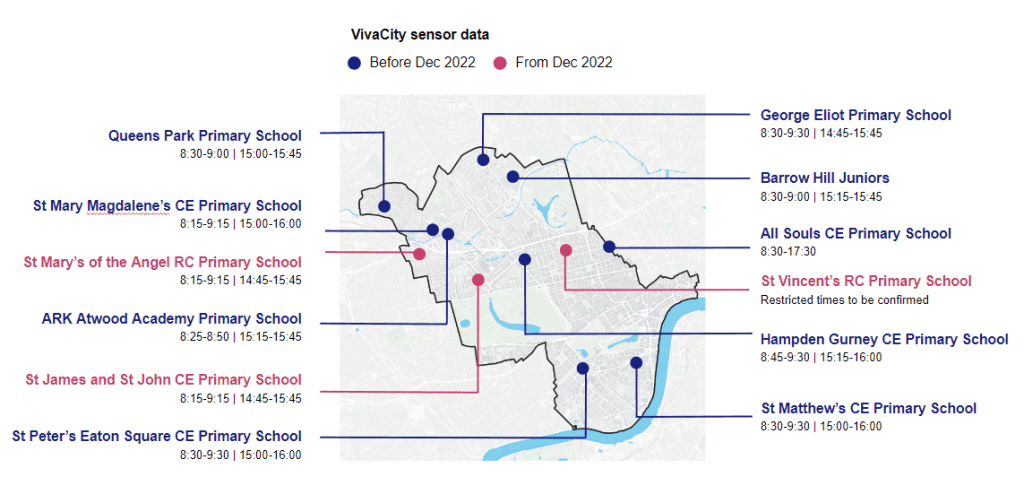
Westminster City Council worked with VivaCity to install traffic monitoring sensors at nine locations. The sensors collect traffic counts and analyse movements of motorised vehicles, pedestrians and cyclists 24/7. Data between January and November 2022 was analysed for an in-depth evaluation of the trial. Alongside this quantitative data, the council gathered qualitative views on the schemes using a feedback questionnaire.
In March 2023 the council announced that 11 School Streets will be made permanent and that they will continue to install School Streets for the next 3 financial years.
Map of School Street Trials
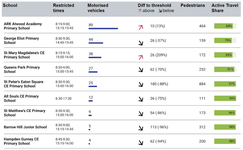
Overall there is good compliance with the School Streets
Average hourly motorised vehicle counts are fairly low across all sites ranging between 4 and 89 vehicles per hour. To understand the success of the schemes, motorised traffic volumes during restrictions are compared against hourly tolerance levels. Only two School Streets record hourly motorised vehicles above the set threshold (ARK Atwood Academy, St Mary Magdalene’s). Evidence therefore suggests that School Streets are successful in removing or reducing motor vehicles.
Average hourly counts during restricted times per month and comparison against threshold (tolerance level)
Data shows little change over time
Average motorised traffic volumes during restricted times are fairly consistent over time. However, due to the short monitoring period, it is difficult to draw conclusions about the long-term impact of the schemes at this stage. Four School Streets show a more notable difference in motorised vehicle counts between morning and afternoon restrictions.
Average hourly counts during restricted times per month and comparison against threshold
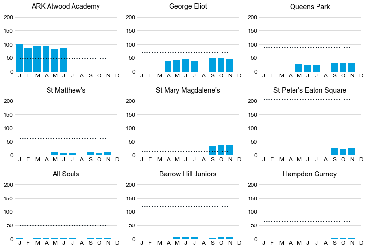
Note: Data since July has been excluded for ARK Atwood Academy
Average motorised traffic volumes vary greatly by day
Average motorised traffic counts vary greatly on a daily basis across all sites, especially at ARK Atwood Academy and George Eliot. Outliers for some sites could be linked to specific school events or roadworks leading to diversions.
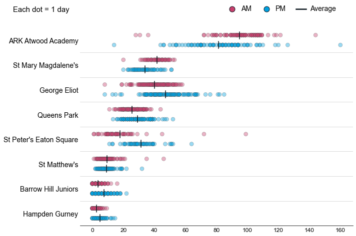
Morning restrictions see more vehicles at ARK Atwood Academy and St Mary Magdalene’s. Afternoon restrictions see higher vehicles at St Peter’s Eaton Square and George Eliot. Differences between AM and PM are less pronounced at the other sites.
Average hourly counts per day during restricted times
Pedestrian tracks suggest safe environments for walking
Pedestrians make good use of pavements across all sites, but tracks also show a fair amount of crossing behaviour at non-prescribed crossing locations as well as pedestrians walking on the carriageway. This might suggest that students feel comfortable moving freely around the School Streets.
Cyclist counts at all sites are low, suggesting that not many students or their parents/guardians are cycling to school.
All Souls CE Primary School, Wednesday 16/03/2022 8:30 – 9:30

St Mary Magdalene CE Primary School, Wednesday 12/10/2022 8:15 – 9:15

How is Westminster City Council using the data?
Using detailed traffic data from VivaCity has enabled Westminster City Council to understand general compliance with the School Street schemes as well as Active Travel volumes. Data has shown that even before enforcement cameras were put in place, average motorised traffic counts were relatively low across all sites. Only two sites recorded levels above the threshold, suggesting that the schemes have been successful in reducing motorised traffic.
Together with consultation responses, VivaCity data informed the council’s decision to make 11 School Streets permanent and to continue installing School Streets for the next three financial years.
Data from individual schools can support further interventions at specific sites and serve as a baseline for follow-up evaluations. Westminster City Council is also thinking about how to integrate VivaCity data into more holistic frameworks such as the Healthy Streets Framework to assess the impact of the School Streets.
“VivaCity data has played an important role in the evaluation of the School Streets trial. The data has helped to substantiate and give context in conjunction with the online School Streets feedback questionnaire responses, along with informing the decision-making process as to which trial sites were to be made permanent. Traffic volumes, active travel volumes and tracks (desire line) data is a key component in the ongoing monitoring and evaluation of School Streets. It has helped us to understand and communicate their long-term impact to the local community and at large.”
Carla Leowe, Road Safety Officer, Westminster City Council
Want to learn more about Westminster’s monitoring and evaluation approach?

DOWNLOAD THE FULL REPORT NOW
Want to learn more about how VivaCity data can be used for Monitoring and Evaluation?
You might also be interested in:
Our Solutions | Our Products | Other News & Case Studies | About us