
This year is looking promising for Local Authorities that are engaged in Active Transportation schemes. Invitations for funding applications have recently been announced, including expressions of interest in Mini Hollands, capital funding for 2021/22, the GP Prescribing Pilot fund, as well as ‘Healthy Streets Funding’ through Transport for London.
A critical element of the application criteria specifies the need for effective scheme monitoring and evaluation.
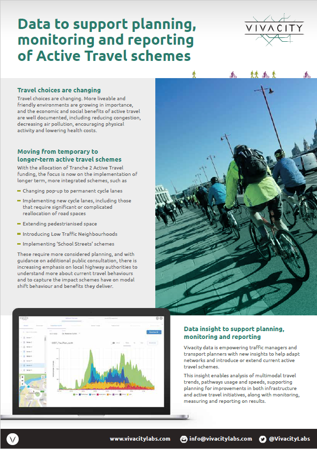
With increasing demand for improved consultation, there is now greater pressure on authorities to understand current travel behaviors. This is particularly important when it comes to capturing the impact new schemes have on modal shift behavior and the benefits they deliver.
So how can this be achieved to ensure that funding applications have the highest chance of being successful?
The answer is with quality, accurate, and timely data.
Using artificial intelligence-powered traffic sensors for monitoring and evaluation
Viva offers an AI-powered sensor that provides highly accurate and up-to-the-minute data on transport modes, traffic flow and travel patterns.
One of our sensors alone can provide insights on a whole array of different road users. It can anonymously identify nine different classifications (soon to be 32), including pedestrians, cyclists and e-scooters, and how they interact with each other.
These data insights give authorities the ability to analyse multimodal travel trends through counts (e.g., 15 cyclists, 8 pedestrians), behavior, pathways and speeds of road and path users – in real time. Councils can access detailed insights into current interactions in the area, showing overall changes in travel and micro-trends in local active transportation uptake, for example.


Leveraging Active Transportation scheme monitoring with data
The Before: Planning implementation
A thorough and careful study of the existing traffic pattern in the area is ideal, to set up comparison benchmarks, and for the ideation of intended traffic and road use goals. The onus is on authorities to implement long-term infrastructure changes and facilitate the growing demand for active transportation and sustainability. Such changes include making temporary cycle lanes permanent, creating new cycle lanes, extending pedestrianised space and introducing Low Traffic Neighbourhoods.
For councils to know where to implement such schemes, they need to have the right data. ‘Fail to prepare, prepare to fail’ rings true here. Schemes that are introduced with limited insight into how roads and pavements are already being used will risk their success.
The During: Real-time data insight
This same insight is just as crucial for when the schemes have been implemented. Collecting this anonymous data on the coverage of cycle lanes is incredibly valuable, with a single AI sensor able to provide data for a segregated cycle lane, a footpath next to the road, and a mixed carriage way, among others.
If a new segregated cycle lane has been introduced, the sensor can assess, firstly, how much the lane is being used by cyclists: for example, has there been an increase in cyclists along the route from before? Are cyclists using the lane instead of the road? Secondly, the effect the lane is having on other road users: has it reduced (or increased) the use of private vehicles, congestion and emissions? This can all be accumulated through AI sensors placed at specific junctions or positions along target routes.
Councils can then easily download this data via cloud-based dashboards. With this enhanced insight, schemes and networks can then be adapted, extended or reduced depending on what the data shows.
The After: Evidence
With this data, authorities then have the ability to provide objective ‘before, during and after’ evidence for the benefits of such schemes and whether they have contributed to a mode shift in travel. Monitoring and reporting after the scheme has been implemented is also fundamental for consultation purposes and to settle any debates that may arise.
For example, last summer, with Viva sensors installed in the area, Westminster City Council had data to study the impact of measures to discourage vehicle congestion by increasing footpath space to improve social distancing.
Following the introduction of an intervention in St John’s Wood in early July, with extra space accommodating more people walking at a distance, data showed that all motorised vehicle volumes dropped to 70% below normal (before) levels and pedestrian rates steadily increased to above 145% compared to June conditions. Despite the preference for taking personal vehicles during this time, data supported the positive impact of the intervention in prioritising active transportation and reducing traffic.
With data readily available, the benefits of the scheme – before, during and after – were there for all to see.
Some of our customers
We have been working with a wide range of councils across the UK on their respective active transportation schemes, and have a wealth of information on how to best plan and implement active transportation monitoring schemes.
Here are some of our customers stories and active transportation use cases:
- Westminster Council – analysing active transportation schemes using Viva data
- Sutton and Kingston Councils use Viva technology to improve the understanding of cycle lanes usage
- Viva sensors will give new insights into people and transport movements in Richmond’s busiest areas
To find out more about our traffic management solution, please visit our technology page and get in touch with our team now.
Other active transportation scheme resources and references
- The Cycle infrastructure design / Local Transport Note 1/20 Guide offers a thorough explanation of how cycling schemes should be implemented.
- Gear Change: A bold vision for cycling and walking is an initiative aimed at supporting cycling and walking how to get England moving differently, as it sees an important role these can play in our transport system.
- The London Extraordinary funding and financing package page explains in more detail the funding available for London councils.
- Active Travel Fund: Local Authority Capital Funding for 2021/22 and expressions of interest for Mini Hollands and GP Prescribing Pilot letter from the Department for Transport – deadline for applications is Monday 9 August, 2021.
Like our content? Sign up to our newsletter and receive the latest updates in your inbox.
Sign-Up